
 admin
admin
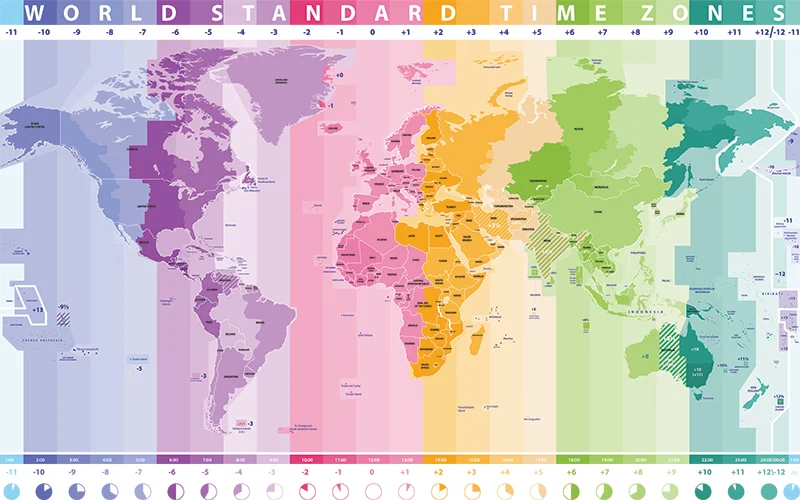
The Strange Shape of Time Zones: Understanding How They Are Determined
Most people are aware that the Earth is divided into 24 time zones, but many might not understand why these time zones appear in such irregular shapes on the map. Time zone boundaries are not straight, and their unusual patterns raise a fascinating question: why are they designed this way? To answer that, we need to explore the history and logic behind time zones and how they are influenced by geographical, political, and social factors.
The Origin of Time Zones and UTC
The modern system of time zones begins at the Prime Meridian, which is located in Greenwich, England, and is defined as 0 degrees longitude. This meridian is the reference point for Coordinated Universal Time (UTC), a standard used worldwide. Time zones are then calculated as offsets from UTC, with locations to the east of Greenwich having a positive offset (e.g., UTC+7), and those to the west having a negative offset (e.g., UTC-5).
For example, Jakarta, the capital of Indonesia, is located in the UTC+7 time zone. This means that the local time in Jakarta is seven hours ahead of UTC.

Why Time Zones Aren’t Straight Lines
Although the concept of time zones suggests that they should be evenly spaced at 15 degrees of longitude (as the Earth rotates 360 degrees in 24 hours), reality paints a different picture. If time zones were straight vertical lines, they would create various problems, particularly in regions where cities or even individual towns might straddle two time zones. Imagine driving across a county line and suddenly having the time jump forward or backward by an hour. This would cause significant confusion in everyday life, including for transportation schedules, work hours, and even social interactions.
A good example of this potential chaos is found in Magetan Regency in East Java, Indonesia. If the time zone boundaries were strictly drawn based on the 15-degree intervals, Magetan could be split between UTC+7 and UTC+8, resulting in a one-hour time difference within the same county. This would not only confuse residents but also complicate regional coordination and economic activities. To avoid such discrepancies, time zone boundaries are often adjusted to follow national borders and regional boundaries, ensuring that communities within the same country or region share the same time.

Time Zones Across the World: France vs. China
Countries handle time zones in various ways, depending on their geography, politics, and history. One notable example is France, which holds the record for the most time zones of any country—12 in total. This is not because mainland France spans such a wide area, but due to France’s numerous overseas territories scattered around the globe, including regions in the Caribbean, the Indian Ocean, and the Pacific. Each of these territories uses a different time zone, reflecting their geographical locations relative to UTC.
In contrast, China, a vast country that technically spans five time zones, has chosen to use only one official time zone: China Standard Time (UTC+8). This decision is rooted in the desire for national unity and centralization. However, this creates a unique situation for cities in western China, such as Kashgar, where the sun may not rise until after 10 AM. While this single time zone simplifies governance and national coordination, it also leads to noticeable discrepancies between clock time and natural daylight in different parts of the country.
The Practical Need for Irregular Time Zones
The seemingly odd shapes of time zones are necessary to accommodate human activity, economic needs, and national borders. While the Earth’s rotation gives us a natural framework for dividing time into 24 segments, the complexities of geography and politics mean that we need to adapt time zones to better fit societal realities. By following political borders and regional divisions, time zones can avoid splitting cities, regions, or countries into different time settings, reducing confusion for those living and working within them.
In the end, time zones are a blend of astronomical principles and human convenience. While the Earth’s rotation provides the baseline for measuring time, it’s the nuances of our social and political world that determine the shape and boundaries of each time zone.
Popular Posts




Categories
Tags

Comments