
 admin
admin

In the world of geospatial data collection and mapping, Photogrammetry and LiDAR (Light Detection and Ranging) are two of the most prominent technologies used to create highly accurate 3D models and maps of the Earth's surface. Both methods offer powerful solutions for industries such as construction, forestry, mining, urban planning, and environmental monitoring. However, despite their shared goals of capturing spatial data, these two technologies operate in very different ways, each with its own strengths, limitations, and ideal use cases.
In this article, we’ll explore the key differences between photogrammetry and LiDAR, breaking down how they work, their applications, and which situations may call for one technology over the other.
What is Photogrammetry?
Photogrammetry is the science of making measurements from photographs, typically captured from aircraft, drones, or satellites. By analyzing overlapping 2D images taken from different angles, photogrammetry software can generate 3D models, digital elevation models (DEMs), and detailed maps. This is achieved by applying geometric principles to determine the location, distance, and dimensions of objects within the photos.
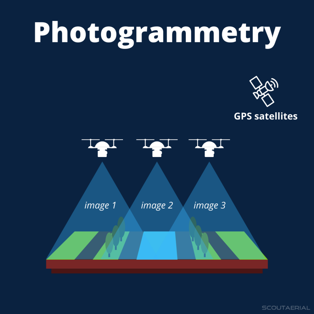
Key characteristics of photogrammetry:
- Uses optical images captured with regular cameras.
- Requires overlapping images to generate 3D data.
- Relies on stereoscopy to calculate depth and distances from multiple perspectives.
- Generates high-resolution texture maps of the surface, often producing visually detailed models.
Photogrammetry is popular due to its versatility, cost-effectiveness, and ability to generate both 2D and 3D representations of the terrain. With the rise of drones and improved software, photogrammetry has become accessible for a wide range of projects, from surveying large landscapes to documenting cultural heritage sites.
What is LiDAR?
LiDAR (Light Detection and Ranging) is a remote sensing technology that measures distances by sending out pulses of laser light and analyzing the time it takes for the light to return after reflecting off objects. These measurements, known as point clouds, are used to create highly accurate 3D models of the Earth's surface. Unlike photogrammetry, LiDAR doesn’t rely on cameras to capture images but instead uses lasers to scan and measure the environment directly.
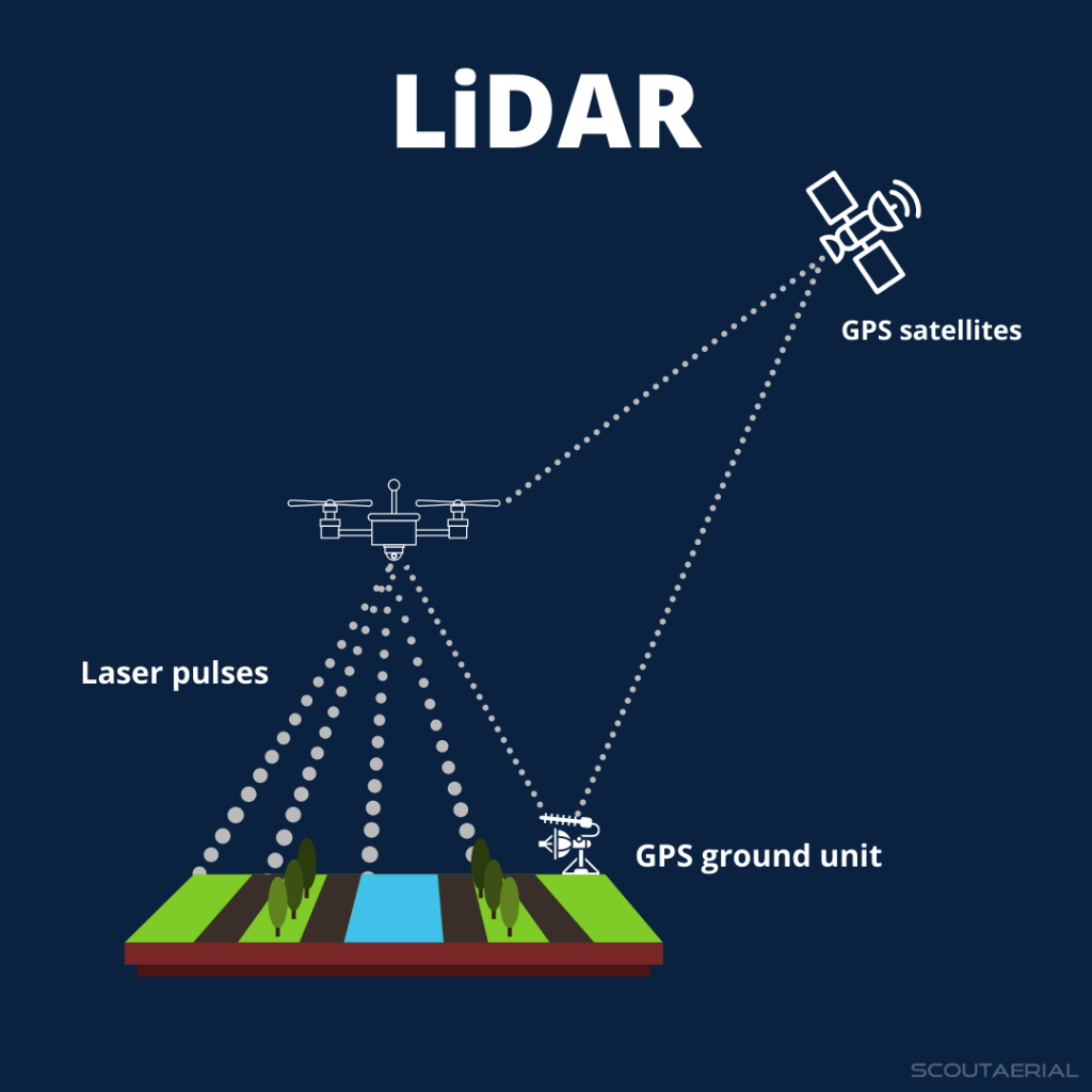
Key characteristics of LiDAR:
- Uses laser pulses to measure distances.
- Generates a point cloud of precise 3D coordinates.
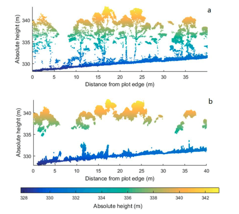
- Works in low-light conditions and can penetrate obstacles like vegetation to capture the ground surface beneath.
- Offers highly accurate elevation data and models, often used for detailed topographic mapping.
LiDAR is widely used in areas where high precision is required, such as terrain modeling in forestry, flood risk analysis, and infrastructure development. It is also effective in areas with dense vegetation, where photogrammetry struggles to capture accurate data about the ground surface.
How They Work: Photogrammetry vs. LiDAR
Although both photogrammetry and LiDAR are used to create 3D models and maps, they rely on fundamentally different approaches:
1. Data Capture Method
- Photogrammetry: Captures images using cameras. These images must overlap by 60-80% to enable 3D reconstruction. The method depends on analyzing the differences in these images to calculate distances and create 3D models.
- LiDAR: Uses laser pulses to measure the distance between the sensor and objects on the ground. Each laser pulse returns a point of data, resulting in a point cloud that represents the surface geometry.
2. Type of Output
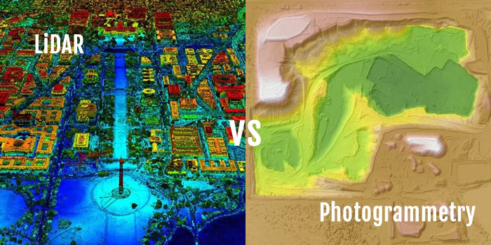
- Photogrammetry: Produces 2D orthophotos (geometrically corrected aerial images) and 3D textured models, where the visual appearance and texture of the surface are captured in high resolution. It is ideal for creating visually detailed maps and models.
- LiDAR: Outputs a point cloud, which is a set of millions of precise data points representing the geometry of the surface in 3D. The point cloud is highly accurate but lacks the detailed surface texture that photogrammetry provides.
3. Accuracy
- Photogrammetry: The accuracy of photogrammetry depends on the resolution of the images and the quality of the camera. It can produce highly accurate 3D models, but the data may be less reliable in areas with heavy vegetation, poor lighting, or large uniform surfaces (like deserts or snowfields).
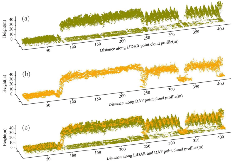
- LiDAR: LiDAR is known for its high precision, especially in measuring elevation. It can penetrate vegetation to measure the ground beneath, making it superior for topographic mapping in forested or densely vegetated areas.
4. Penetration through Vegetation
- Photogrammetry: Struggles with dense vegetation because it relies on the visual capture of the surface, meaning it cannot easily see beneath tree canopies or other obstructing objects.
- LiDAR: Can penetrate through vegetation to measure the bare ground, providing accurate topographic data even in forested or heavily vegetated environments.
5. Environmental Conditions
- Photogrammetry: Requires clear weather and good lighting conditions for optimal image quality. Cloud cover, shadows, and low light can negatively affect the results.
- LiDAR: Can operate in various lighting conditions, including at night or in overcast conditions, since it relies on laser pulses rather than visual images.
Applications: When to Use Photogrammetry vs. LiDAR
Photogrammetry Use Cases:
- Urban Planning and Architecture: Creating 3D models of cities, buildings, and infrastructure for visualization and analysis.
- Cultural Heritage Documentation: Detailed 3D reconstruction of historical sites, monuments, and artifacts.
- Construction Monitoring: Tracking progress by generating frequent 3D models of construction sites.
- Aerial Mapping: Generating 2D maps and 3D models of landscapes for GIS applications.
LiDAR Use Cases:
- Forestry and Environmental Monitoring: Creating accurate terrain models in forested areas and monitoring forest canopy structure.
- Flood Risk Analysis: Detailed topographic mapping to predict water flow and flood risk areas.
- Transportation and Infrastructure Development: Mapping roads, railways, and pipelines with high accuracy for engineering projects.
- Archaeological Surveying: Detecting ancient structures hidden under vegetation or soil layers.
Pros and Cons of Photogrammetry vs. LiDAR
Photogrammetry Advantages:
- Lower cost: Photogrammetry equipment (cameras, drones) is generally more affordable than LiDAR sensors.
- High-resolution visuals: Produces detailed images with texture and color, ideal for creating realistic 3D models.
- Widespread accessibility: With the advent of drones, photogrammetry has become more accessible for smaller projects.
Photogrammetry Disadvantages:
- Limited in dense vegetation: Struggles to capture accurate data beneath tree canopies.
- Dependent on lighting: Poor weather or lighting conditions can reduce image quality and accuracy.
LiDAR Advantages:
- Precision and accuracy: LiDAR is highly accurate, especially in capturing elevation data.
- Vegetation penetration: Can measure the ground beneath vegetation, making it ideal for topographic mapping in wooded areas.
- Works in low light: LiDAR can function in various lighting conditions, including at night.
LiDAR Disadvantages:
- Higher cost: LiDAR sensors and systems are generally more expensive than photogrammetry setups.
- Lacks visual detail: While LiDAR provides precise data, it doesn’t capture surface textures or colors, making it less ideal for visual representation.
Conclusion
Both photogrammetry and LiDAR are essential tools in the geospatial industry, each offering unique benefits depending on the project’s goals. Photogrammetry is ideal for projects requiring detailed, high-resolution visuals and is more cost-effective for many general mapping tasks. On the other hand, LiDAR excels in precision and is indispensable for terrain mapping in forested areas, infrastructure projects, and environments where accuracy is critical.
Choosing between photogrammetry and LiDAR depends on the specific needs of the project—whether you prioritize texture and visual detail or raw accuracy and the ability to capture data in dense vegetation.
Popular Posts



Categories
Tags

Comments