
 admin
admin

Photogrammetry is a branch of geospatial science that involves obtaining reliable measurements and spatial information about physical objects and environments through the analysis of photographs. Specifically, aerial photogrammetry is the process of taking measurements from photographs captured from the air, typically using drones, airplanes, or satellites. This technique is widely applied in mapping, surveying, and creating 3D models of large areas of the Earth's surface.
The core concept of photogrammetry relies on stereoscopy, which involves taking two or more photographs of the same area from different angles. By analyzing these overlapping images using geometric algorithms, it becomes possible to extract accurate three-dimensional information about the terrain, structures, or any features visible in the photographs. The mathematical principles used include trigonometry, projective geometry, and computer vision.
In this article, we’ll explore what aerial mapping through photogrammetry is, how it works, and its diverse applications.
What is Aerial Photogrammetry?
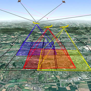
Aerial photogrammetry involves capturing overlapping photographs of the Earth's surface from an elevated position, usually via aircraft, drones, or satellites. These images are then processed and analyzed to extract precise geographic information. The resulting data is used to create accurate 2D maps, Digital Elevation Models (DEMs), and 3D models of the terrain.
The key to photogrammetry lies in its ability to extract measurements from two or more photographs taken from different angles. By applying geometric principles, software can calculate the position and distance of objects in the images, allowing for accurate reconstructions of the landscape.
Scientific Principles of Photogrammetry
The foundation of photogrammetry is built on the following scientific principles:
- Geometric Perspective: Photographs are 2D projections of 3D objects. By comparing multiple photographs of the same object taken from different positions, it is possible to reconstruct the object's 3D shape and size.
- Parallax: This refers to the difference in position of an object when viewed from two different perspectives. By measuring parallax in overlapping images, the depth and distance of the object can be calculated.
- Triangulation: Using known points in space (such as ground control points), the positions of other objects in the image can be calculated through triangulation, a method that relies on the geometric relationship between two known points and the object being measured.
This process yields highly accurate measurements and is crucial for creating detailed and scaled maps, digital elevation models (DEMs), and orthophotos, which are geometrically corrected aerial photographs.
Types of Photogrammetry
- Terrestrial Photogrammetry: Images are captured from ground-based cameras. It is commonly used for documenting buildings, infrastructure, and smaller-scale features.
- Aerial Photogrammetry: Photographs are taken from above the Earth’s surface, providing a large-scale view ideal for mapping large areas. This method is used for terrain modeling, topographical surveys, and urban planning.
Aerial photogrammetry has been instrumental in advancing remote sensing and geospatial science, providing the ability to map, analyze, and monitor the Earth's surface in unprecedented detail.
How Does Aerial Photogrammetry Work?
The process of aerial photogrammetry involves several steps, from capturing the images to processing them into usable maps and models. Here’s a breakdown of how the photogrammetry workflow typically operates:
1. Image Acquisition
The first step is capturing aerial images. This is typically done using drones (Unmanned Aerial Vehicles, UAVs), airplanes, or satellites equipped with high-resolution cameras. The images must have enough overlap (usually 60-80%) to allow for 3D reconstruction. Overlapping images ensure that every point on the ground appears in at least two photos from different perspectives.
2. Georeferencing
Georeferencing involves assigning spatial coordinates to the images. Using GPS (Global Positioning System) data and sometimes ground control points (GCPs), each photo is aligned to real-world coordinates. This step is crucial for ensuring that the resulting maps and models are geographically accurate.

3. Image Processing and Alignment
Once the images are captured and georeferenced, specialized photogrammetry software like Agisoft Metashape, Pix4D, or DroneDeploy is used to process the images. The software identifies common points in overlapping images and aligns them based on their relative positions. This allows for the creation of a seamless mosaic or 3D reconstruction.

4. 3D Modeling and Map Generation
After the alignment, the software generates a point cloud (a set of data points in space representing the 3D shape of the surface). From the point cloud, further models are created:
- Orthophotos: Aerial photos that have been geometrically corrected so they can be used as accurate maps.
- Digital Elevation Models (DEMs): These represent the surface elevation of the terrain, including buildings, vegetation, and other features.
- 3D Models: Detailed 3D reconstructions of the terrain, which can be used for various analyses and visualizations.
5. Analysis and Output
Once the photogrammetric data is processed, it can be exported in various formats for use in GIS (Geographic Information Systems) software, CAD (Computer-Aided Design) systems, or even VR/AR platforms. The data can then be analyzed for different applications, such as land-use planning, infrastructure development, or environmental monitoring.
Applications of Aerial Photogrammetry
Aerial photogrammetry has revolutionized numerous industries by offering a highly efficient and accurate means of surveying and mapping large areas. Here are some key applications:
1. Agriculture
In precision agriculture, aerial photogrammetry is used to monitor crop health, analyze soil conditions, and optimize irrigation. By generating high-resolution maps of farmland, farmers can make data-driven decisions that improve yield and reduce waste.
2. Construction and Urban Planning
Aerial mapping helps construction companies survey large sites quickly, assess topography, and monitor progress. It’s also used in urban planning to map out new developments, assess infrastructure, and create 3D models of buildings and terrain.
3. Mining
In the mining industry, aerial photogrammetry is used for volumetric measurements, helping companies calculate the volume of material extracted or to be extracted. This method is faster and safer than traditional ground surveys, especially in hazardous environments.
4. Environmental Monitoring
Photogrammetry provides a non-invasive way to monitor environmental changes, such as deforestation, erosion, or coastal changes. High-resolution 3D models allow for detailed analysis of ecosystems and the detection of subtle changes over time.
5. Disaster Management
In disaster response scenarios, photogrammetry enables rapid assessment of damage after natural disasters such as earthquakes, floods, or hurricanes. Accurate maps and 3D models help responders understand the scale of the damage and coordinate relief efforts.
Advantages of Aerial Photogrammetry
1. Cost-Effective
Compared to traditional ground-based surveying methods, aerial photogrammetry is often more cost-effective, especially for large areas. Drones, in particular, offer a low-cost way to collect detailed aerial imagery.
2. High Accuracy
Modern photogrammetry techniques, combined with advanced GPS technology, allow for highly accurate measurements. This makes it ideal for applications where precision is critical, such as construction, mining, or environmental monitoring.
3. Time-Efficient
Aerial photogrammetry can cover vast areas in a short amount of time, making it much more efficient than traditional methods, especially for projects like land surveying, urban planning, or environmental monitoring.
4. Safe Data Collection
Using drones or aircraft for data collection minimizes the need for surveyors to access dangerous or difficult terrain. This reduces the risk of accidents, especially in hazardous environments like active construction sites or disaster zones.
Challenges and Limitations
While aerial photogrammetry offers many advantages, it’s not without its challenges:
- Weather Dependence: Poor weather conditions, such as heavy rain, wind, or cloud cover, can affect image quality and disrupt data collection.
- Processing Power: The image processing stage requires significant computational resources, especially when working with high-resolution data and large areas.
- Ground Control Points (GCPs): For high-accuracy mapping, GCPs are often needed to improve the georeferencing accuracy. Placing and measuring these points can add time and cost to a project.
Aerial Photogrammetry in Practice
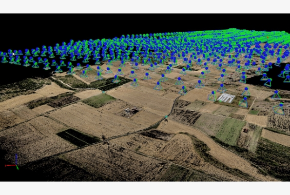
In practice, aerial photogrammetry involves capturing hundreds or thousands of overlapping images across a specified region. These images are processed through specialized software that aligns the photographs, corrects for distortions, and applies georeferencing—assigning geographic coordinates to each pixel in the image based on GPS data. Advanced computer vision techniques allow the generation of point clouds, from which 3D models and terrain maps are constructed.
A common use of photogrammetry is in GIS (Geographic Information Systems) for creating detailed spatial datasets that can be used for land-use planning, disaster management, and environmental monitoring.
In conclusion, aerial photogrammetry is a powerful scientific tool that merges photography, geometry, and modern computational techniques to produce precise geographic data, revolutionizing fields such as cartography, urban planning, and natural resource management.
Popular Posts



Tags

Comments